
Shushtar Historical Hydraulic System
- UNESCO World Heritage Site (since 2009)
- Address : Kargar Sq., Shushtar
- Opening Hours : Summer : 08:00-20:00 / Winter : 08:00-17:30
- Entrance Fee : 50T
- Historical Period(s) : Achaemenid and Sassanid
- Tel. : 061-26228930
- Recommended Time to Spend : 1-2 hours


- Khuzestan Province
- Shushtar
2
3
Known as a masterpiece of creativity, engineering, and art by the UNESCO, traced back to the Achaemenid period, the reign of Darius the Great, in the 5th century B.C. It’s one of the greatest industrial complexes in the world existing in the pre-industrial revolution era.
This hydraulic system consists of :
- Mizan Dam: regulating water between Shatit and Gargar branches of Karun River.
- Kolah Farangi Tower: A monitoring post for water diversion
- of Gargar canal, a diversion if Karun river, serving for both hydropower, irrigation, and fortification for the city of Shushtar.
- Gargar Bridge-Dam: For increasing the water head and a bridge
- Waterfalls and Watermills Area: Hydropower & Recreational Site
- Borj-e-Ayyar Bridge-Dam: Bridge and water regulation
- Khoda-Afarin Bridge-Dam: Bridge and water regulation
- Salasel Castle: Water System operation and command center
- Dariun Canal: Water diversion
- Shadorvan (Caesar’s) Bridge-Dam: Bridge and Water regulation
- Khak Dam: water regulation
- Lashkar Bridge-Dam: water regulation and bridge
- Sharabdar Dam: water regulation
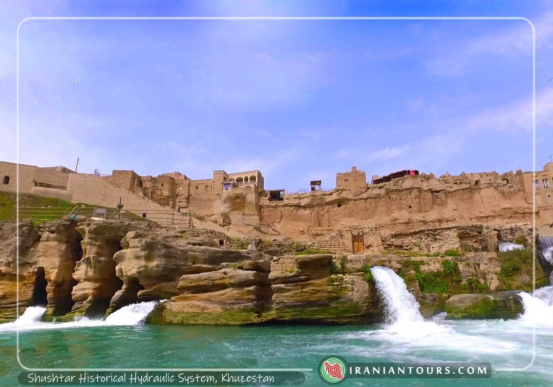
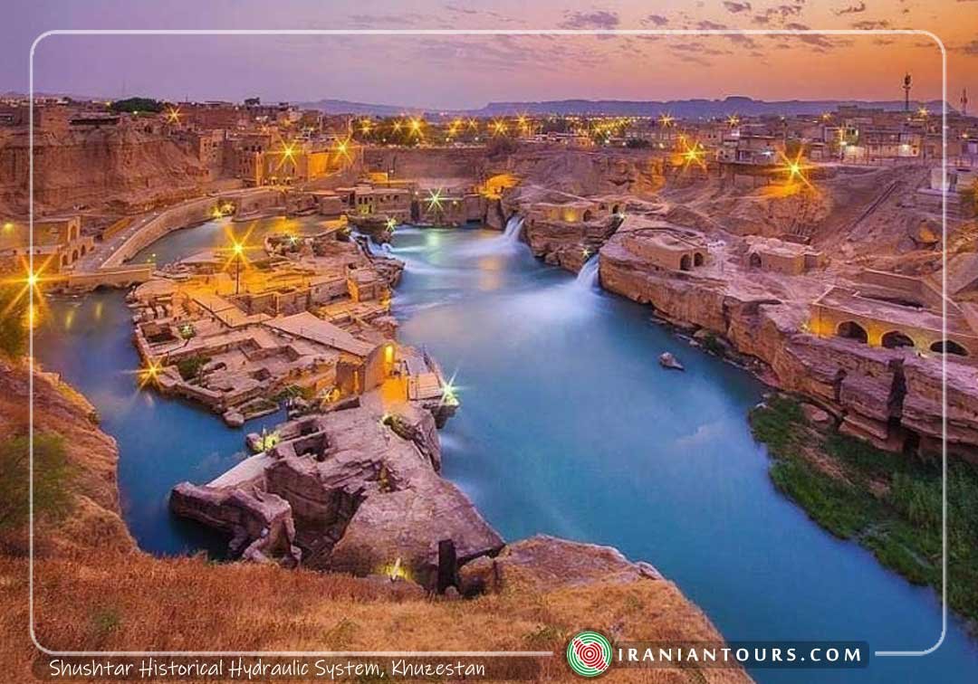
Gargar Bridge Dam
Gargar Bridge was one of the important gates of Shushtar, stretching from east to west. Located at the north of the waterfalls, this canal dates back to the Sassanid era (224-650). However, the current brick structure dates back to the Safavid era. This bridge diverts the water from Gargar River and leads it to the mills. It is 83 m long, 12 m wide and 6 m high, located 800 meters lower than Mizan dam.
Gargar Canal
The Gargar Canal is separated from the Karun River by Mizan Dam (or Band-e-Mizan). After flowing 100 km, it rejoins Karun in the southern part of the city.
This canal is located at the beginning of the city, fulfilling several functions such as: irrigating the agricultural lands in the south of Shushtar, providing a passageway for the commercial ships, reducing the river’s discharge to prevent its flooding, and preventing the enemy’s advance into the city by forming a moat-like structure. The water of the canal is also conducted to the watermill system to rotate the wheels of the mills.
Watermill System
The watermill system is located on the east of Shuhtar. Covering an area of 5 hectares, this complex includes 50 water mills built by lime, mortar, granite, and sarooj (water-resistant mortar). In the Achaemenid era, the mills were used to grind wheat but during modern times, the water was transported to ice manufacturers, located in the western part, and to help generate electricity.
Lying along the Gargar Bridge, this ensemble of waterfalls and mills is divided into three sections: the eastern part used to hold twelve mills, each mill having two stones. Of these mills, only eight have survived the test of time. The northern part contains six watermills which are newer in comparison to the other mills of the complex. The western part used to be comprised of 21 mills, a stone-staircase with 115 steps, and a Chahar taqi room (a four arches room) which functioned as the resting area of the millers.
Band-e Borj-e Ayar (Sabei Kosh)
The dam of Borj-e-ʻAyār lies across the Gargar River, at the south-east of Shushtar. Located in the lower part of the historical mill area, this hand-dug structure dates back to the Sassanid era (224-650 A.D.). This dam was used to irrigate its surrounding gardens by bringing up the level of water.
The area known as Band-e Ayar is also famous as Sabei Kosh or Sabei, derived from a tragic historical event that took place in this area. As the story goes, the Sabeins (Mandaeists) living in this area were slaughtered by a group of religious fanatics and after this event, the area became known as Sabei Kosh (a place where the Sabeis were killed). There is also a Sabein temple on the eastern part of the Borj-e-Ayar Dam, consisting of several rooms, a pond, and three canals which provided the sanctuary with water from the dam. Based on the available historical information, the sanctuary was in use up to the last days of the Qajar era (20th century).
Band-e Mahibazan
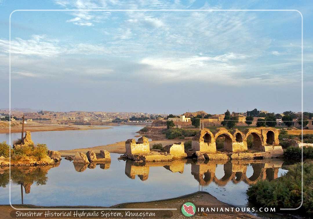
There are two dams, called Borj-e-ʻAyar and Band-e Mahibazan, on Gargar River. The main function of Band-e Mahibazan, also known as Band-e Khoda Afarin, was to raise the level of water and connect the two sides of the ancient city of Dastova, located in the south of Shushtar. Some records show that the dam is called Mahibazan (fishers) since it is a popular place for fishing. Dating back to the Sassanid era (224-650 A.D.), this dam is 500 m long, 2 m wide and 2 m high, and is made of sandstones and rocks collected from the area.
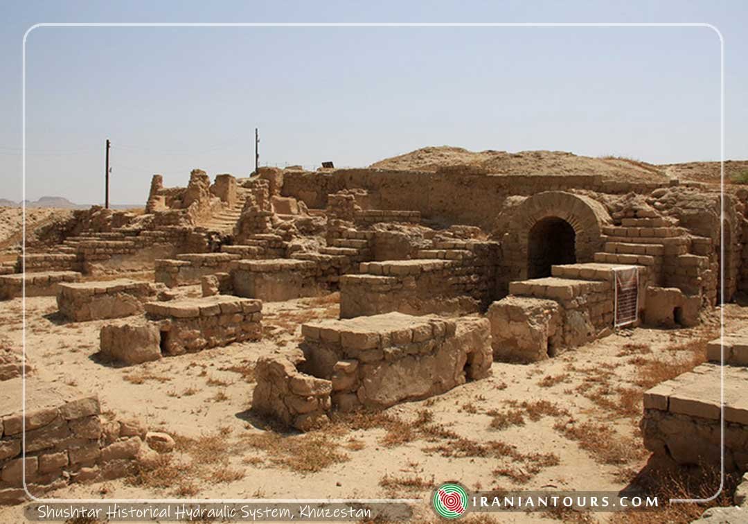
The Castle of Salasel
Salasel castle, sitting along one of the branches of the Karun River, Shoteit, dates back to the Achaemenid period. Aside from its defensive character, this fortress was home to the ruler of Khuzestan. The entire hydraulic system of Shushtar was controlled from this place. Another outstanding feature of the fortress was controlling the Dariun stream, distributing its water in the southern lands.
Located at the north-west of Shushtar, Salasel Castel is surrounded by a moat on the south and southeast and Dariun River on the north. It is recorded that the castle used to be a comprehensive structure, containing several courtyards, public bathrooms, military camps, a kitchen, a pond, etc. The castle was destroyed due to successive wars, earthquakes, and floods; however, evidence indicates that the castle remained prosperous until 50 years ago.
According to the legends, the name of Salasel is attributed to the servant of the ruler of Fars who rose against his ruler and sieged the castle for six months. When the ruler surrendered the castle to his servant, Salasel said to the ruler that he had had no intention of rebelling and just wanted to test how long the castle would resist the enemies’ attacks. From that time, Salasel became the ruler of that area and the castle was named after him.
The castle has been renovated several times during the history, although it has lost its former glory. The most important phase of the castle’s reconstruction was in the Qajarid era, during the reign of Fath Ali Shah (1797-1834). The last phase of reconstructions was executed in 1890 by Hossein Qoli Nezam Alsaltane, the Qajarid minister of Mohammad Ali Shah.
Dariun Canal
Dariun stream, 2.5 km long, is one of the most famous hydraulic structures on the Mian-Ab plain. Since the canal was dug during the Achaemenid period (529-330 B.C.), especially during the reign of Darius (521-485 B.C.), it carries the name Dariun. Flowing along the western side of Shushtar, this hand-dug stream irrigates its surrounding farming lands and forty thousand hectares of the Mian-Ab plain.
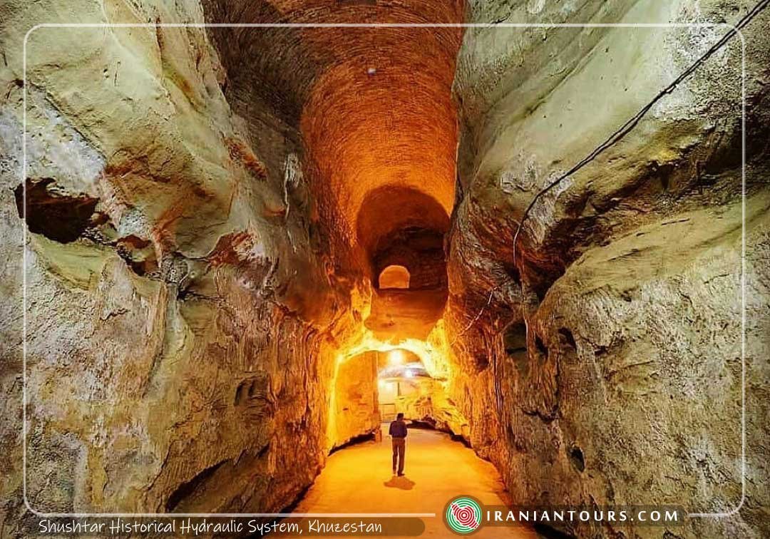
Dariun stream is located on the north of the Salasel castle, feeding into eight water collectors under the Castle. These eight sluices, fed by the Dariun stream, develop into a single canal and flow out of the castle. After passing a course of 800 meters, the canal is divided into two branches at the dam of Band-e Khak. Then, the first branch joins the Shoteit Canal at the dam of Band-e-Qir and the second branch joins the Gargar canal at the Lashkar dam-bridge.
One of the important functions of this dam was to provide the inhabitants of the castle with water at times of war or siege. For this reason, 38 steps were built under the castle to facilitate the inhabitant’s access to water. This stream also used to provide water for the bathrooms inside the castle. Moreover, it surrounded the ancient city of Dastova as a natural moat, protecting it against the enemies. Actually, the city of Dastova owes its life to the presence of the Dariun stream.
Band-e-Qeysar
Band-e-Qeysar or Shadorvan bridge-dam is located in the north-west part of Shushtar. It sits on Shoteit, the main branch of Karun River, and conducts the water into Dariun canal when the level of water in the river increases.
Dating back to the Sassanid era (3rd to 7th centuries AD), Band-e-Qeysar used to be one of the significant entrances to the city. Some records show that the bridge-dam was renovated in Safavid (16th – 18th centuries AD) and Qajarid (18th – 20th centuries AD) eras.
This dam is 550 m long, 10-15 m wide, and 8 m high, holding 44 big sluices and 43 small sluices of which only 25 gates have remained. This bridge-dam was mainly built of blocks and sandstones, by thousands of Roman captives brought to Shushtar by Shapur I, after the war with the Romans (3rd century AD).
Band-e Khak
Khak dam is located in the south-west of Shushtar between the Dariun and Raqat canals. The neighboring structures are the old wall of Shushtar and two columns made from soil, giving their name to the Khak dam, as the word Khak in Persian language is equivalent to the soil.
At this point, the Dariun canal branches off into two streams: one joining the Gargar canal and the other flowing into the Shoteit canal after running 33 km southwards. The Khak dam rises here to prevent the Dariun stream from flooding into the Mian-Ab plain and redirects the water into the Raqat stream. In other words, it functions as a distributor of water between the Dariun and Raqat canals. Built of mortar, rubble, and sandstone, this dam was destroyed mostly due to road construction projects carried out in this area in the 1980s.
Band-e Sharabdar
Band-e Sharabdar (Sharabdar dam) lies on the east-west direction of the Raghat stream, one of the branches of the Dariun canal. This dam is 35 m long, 2 m wide and 1 m high and is mainly built of rubble and sandstone. The name Sharabdar (Sharab literally means wine in Persian language) refers to the grape gardens surrounding this area. The main function of this dam is to raise the level of water in the canal in order to irrigate the neighboring agricultural fields.
Band-e Qir
Located at the south of Shushtar, Band-e-Qir is an ancient dam in Shushtar hydraulic system. Generally speaking, Karun canal is divided into two branches: Shoteit and Gargar. Gargar, about 40-meters wide, is separated from Karun at the north of Shushtar and after flowing some 30 kilometers southward rejoins the main branch of Karun, Shoteit, at the Qir Band. Shoteit and Gargar then run together and merge with Dez River. Then, Dez, after flowing 500 km southwards, joins the Karun River at the historic site of Band-e-Qir, about 100 km south of Dezful.
Kolah Farangi Tower
This octagonal tower was built along the western part of the Mizan dam. Known as Kolah Farangi tower, it was built by the Sassanid kings to observe the construction process of the dam. However, some existing evidence proves that it was used to measure the water level of the river. On the other hand, other records show that it was a guiding tower as it overlooked the Salasel Castle.
The current structure, with a height of 7.5 m and a diameter of 3 m, dates back to the Qajar era.
Mizan Dam
This man-made 390-meter-long structure was constructed on the Gargar River, in the North of Shūshtar. The dam diverts the water from the Karūn into the Gargar canal, dividing the river into two branches.
The dam has been constructed on a base of the rock, and the materials used for building it constitute a mixture of sandstones and mortar. A concrete cement mortar was lately added to the structure in order to cover its surface.
The walls of the dam rise to a height of 4.50 meters. It holds ten spans, nine on the east, and one on the west, which is wider than the others. The width of the spans ranges between 70/1 and 85/2. The remains of some short walls on the eastern corner of the dam indicate the existence of a water mill at this section of the dam in the past.
 Arabic
 Chinese (Simplified)
 Dutch
Dutch English
 French
 German
 Italian
 Japanese
 Korean
 Portuguese
 Russian
 Spanish
 Swedish